
Archive GCPs are well suited to budget-conscious projects that need a fast turnaround, while new collection delivers site-specific accuracy through CompassData’s field-proven process. New collections use dual-frequency GPS and GNSS receivers, total stations, and methods such as static, rapid-static, and RTK surveys. Each point is cross-checked and validated, making new collection an ideal choice when program leads need current, verified control points that match precise project timelines, conditions, and accuracy requirements.
Whether your team needs ready-to-use control for an established site or a custom survey for a new location, CompassData helps turn drone imagery into dependable, survey-grade mapping deliverables.
What Is a GCP Archive?
A ground control point, or GCP, archive is a pre-surveyed and validated collection of control points available for immediate use in mapping projects. CompassData maintains a GCP archive in which each point has been collected and validated through a rigorous, field-proven process.
Archived GCPs eliminate the need for a time-consuming field survey when suitable control already exists near or within a project area. Instead of mobilizing a survey crew, project managers can obtain photogrammetric control points quickly and begin processing aerial imagery sooner.
How Does a GCP Archive Compare With a New GCP Collection?
| Feature | GCP Archive: Pre-Existing | New GCP Collection: On-Demand |
|---|---|---|
| Availability | Immediate download | Typically a 2–4 week survey timeline |
| Cost | Lower cost through reuse of existing data | Higher cost due to mobilization and field time |
| Coverage | Limited to previously surveyed areas | Available for virtually any project location |
| Best fit | Stable, repeat, or time-sensitive mapping projects | New, changed, remote, or highly specific project sites |
Archived control points undergo the same validation process as fresh surveys. CompassData cross-checks each archived point against known control networks, including CORS and national geodetic databases.
Each point includes complete documentation, including coordinates in multiple formats, metadata, site sketches, field photos, and detailed accuracy reports. A photo-identifiable GCP also ensures that the physical mark is visible in aerial imagery, making it easier to locate and use in photogrammetry software.
When Should a Team Buy Ground Control Points From an Archive?
Teams should buy ground control points from an archive when a project site overlaps with previously surveyed areas and the available points meet the project’s required accuracy. This approach works especially well when survey-grade accuracy matters but the schedule cannot accommodate a fresh field visit.
Common use cases include:
- Recurring monitoring at the same site
- Construction progress monitoring with repeat drone flights
- Corridor mapping along pipelines, utilities, roads, or transmission lines
- Large rural or remote areas with existing validated survey data
- Projects that need established photogrammetric control points on a short timeline
The key trade-off is location dependency. Archive coverage is limited to specific areas where points were previously surveyed. If no suitable archived point exists near the site, a new GCP collection is generally the better solution.
Why Archived GCPs Can Reduce Cost and Lead Time
Purchasing from a GCP archive makes financial sense when existing points already meet the project’s accuracy requirements. CompassData validates every archived point through a rigorous, field-proven process that cross-checks coordinates against known control networks such as CORS stations.
This process eliminates the cost and delay of sending survey crews into the field for a new collection when suitable data is already available. For large or remote areas, the time savings can be substantial.
For example, a new GCP collection for a 500-acre rural site may require two days of fieldwork plus post-processing. An archive can provide the same coordinates in minutes when valid points already exist and the original collection meets project specifications. CompassData applies the same standards to every point in its database, including dual-frequency GNSS collection and static survey techniques where appropriate.
What Projects Benefit Most From Archived GCPs?
Repeat mapping of the same geographic area is one of the strongest applications for archived GCPs. Construction site monitoring, for example, may require weekly or monthly drone flights over an active development.
Using photogrammetric control points from the original survey helps ensure that every subsequent map aligns with the baseline model. In contrast, deploying a survey team for every flight cycle can multiply costs without necessarily improving the accuracy of a stable site.
When Does an Archive Not Deliver Enough Value?
Archived points are valuable only when they remain suitable for the current site conditions and accuracy needs. Significant terrain changes can affect the usability of physical markers and may require a fresh collection.
| Scenario | Archive Recommended? | Reason |
|---|---|---|
| Repeat monitoring of stable terrain | Yes | Existing points can remain valid, avoiding new fieldwork. |
| Large remote area with existing survey data | Yes | Archived data can save weeks of travel and mobilization time. |
| Recently disturbed or newly developed site | No | Physical markers may have been destroyed, buried, or moved. |
| Project requiring sub-centimeter vertical accuracy | Depends | Verify the archive accuracy report against the project specifications. |
Landslides, excavation, demolition, vegetation growth, and site redevelopment can make a previously visible point unusable. In those situations, a photo-identifiable GCP from the archive may no longer appear in current imagery. An archive also cannot support a project that requires points in a completely unmapped region.
When Is a New GCP Collection Necessary?
A new GCP collection becomes necessary when no suitable archived points exist for the project area. It is also necessary when site conditions have changed, a higher accuracy threshold applies, or the project requires control points positioned specifically for the current mission.
Without reliable ground control, drone mapping outputs can drift from real-world coordinates by meters rather than centimeters. That positional gap can introduce errors across orthomosaics, digital elevation models, 3D models, and volumetric calculations.
What Distinguishes New Collection From Archived GCPs?
CompassData’s professional survey teams deploy high-precision GNSS equipment, including dual-frequency GPS receivers, GNSS receivers, and total stations, to capture new GCP data in the field. Each point is surveyed using an industry-standard method selected for the project’s location and requirements.
- Static surveys provide maximum accuracy over longer baselines.
- Rapid-static surveys balance field efficiency with sub-centimeter precision.
- RTK surveys provide real-time corrections in accessible terrain and suitable conditions.
The right technique depends on the site and the required deliverable. For example, a remote mining site with dense canopy may require a different approach from an open agricultural field or an active construction site.
How Does Post-Processing Improve New GCP Accuracy?
Every newly collected GCP undergoes post-processing using precise ephemeris corrections. This process refines raw GNSS observations against known satellite orbit data, helping remove atmospheric and clock errors that can degrade consumer-grade positioning.
The result is documented horizontal and vertical accuracy rather than assumed accuracy. Project teams receive quantified error values that can be reviewed against engineering, GIS, or client requirements.
Archived GCPs may still serve nearby or adjacent projects, but only when the original survey conditions, equipment, processing method, coordinate reference information, and accuracy tolerance align with the new project. When terrain has changed, the coordinate epoch differs, or the required accuracy has tightened, a new collection is the clearest path to survey-grade confidence.
What Makes a Photo-Identifiable GCP Valuable?
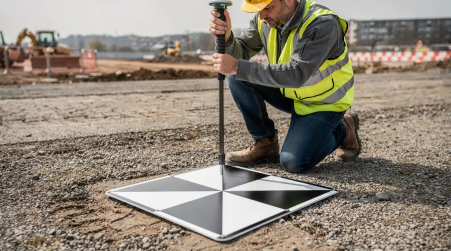
A photo-identifiable GCP is a physical ground marker with known coordinates that remains clearly visible in aerial imagery. These markers form the critical link between drone-captured images and real-world geographic positions.
Without photo-identifiable GCPs, drone maps and 3D models can drift from true locations by meters rather than centimeters. With visible, accurately surveyed control points, mapping teams can tie image data to known coordinates and produce deliverables that are more dependable for planning, measurement, and decision-making.
How Photo-Identifiable GCPs Improve Drone Mapping
Photo-identifiable GCPs improve the georeferencing accuracy of aerial images by ensuring that map pixels align with precise real-world coordinates. This alignment transforms raw drone photos into survey-grade deliverables that engineers, surveyors, construction teams, and GIS managers can use with greater confidence.
They are especially valuable for:
- Volume calculations on earthwork and stockpile sites
- As-built verification against design models
- Construction progress documentation
- Change detection for environmental monitoring and compliance
- Repeat mapping programs that require consistent alignment over time
Why Construction and Surveying Teams Depend on Visible Control
Construction, surveying, and environmental monitoring projects often require more precision than consumer-grade drone positioning can provide. A drone’s onboard GPS may provide approximately 2–5 meters of horizontal accuracy and 3–10 meters of vertical accuracy. Photo-identifiable GCPs can reduce errors to approximately 1–3 centimeters when the survey design, imagery, processing workflow, and site conditions support that level of accuracy.
That difference matters when project decisions depend on reliable measurements, consistent data alignment, and documented quality control.
How Photo-Identifiable GCPs Differ From Standard Survey Markers
Standard survey markers, such as rebar, nails, or painted crosses, can work well for ground crews but may be difficult or impossible to see in drone imagery. A photo-identifiable GCP uses a high-contrast pattern, often a black-and-white checkerboard or crosshair, that is easier to identify in aerial images.
Software platforms such as Pix4D and Agisoft Metashape can use these visible targets during processing, reducing manual point selection and helping minimize human error.
| Feature | Standard Survey Marker | Photo-Identifiable GCP |
|---|---|---|
| Visibility in aerial imagery | Poor or potentially invisible | High-contrast and easier to identify |
| Processing method | Often requires manual identification | Can support automated or easier target detection |
| Typical accuracy contribution | Approximately ±5 cm | Approximately ±1–3 cm, depending on workflow and conditions |
| Field setup time | Approximately 2–3 minutes per point | Approximately 3–5 minutes per point |
For enterprise GIS managers running large-scale drone programs, photo-identifiable photogrammetric control points can reduce rework, accelerate delivery timelines, and create the auditable accuracy documentation that clients and regulators may require.
How Do Photogrammetric Control Points Ensure Accuracy?
Photogrammetric control points provide known coordinates that anchor aerial images to real-world positions. Without fixed reference markers, drone maps and 3D models can drift from true ground locations by meters or more.
The accuracy chain depends on two factors: the precision of the coordinate measurement and the quality control applied to every point. Reliable outcomes require both.
What Validation Steps Confirm GCP Accuracy?
Every point in a professional GCP archive undergoes a multi-stage validation process. Survey teams use high-precision GNSS equipment, including dual-frequency receivers and total stations, to capture field coordinates. The data then passes through several quality checks:
- Cross-referencing against known control networks, including CORS and national geodetic databases
- Post-processing raw GNSS data using precise ephemeris corrections
- Conducting thorough quality control reviews to confirm the data meets or exceeds project specifications
This layered approach helps identify errors that a single-pass survey can miss. A point that passes each stage carries documented confidence and a clearer basis for use in photogrammetric processing.
How Does Accuracy Reporting Build Trust?
CompassData provides accuracy reporting that quantifies both horizontal and vertical error for every point. This transparency gives GIS managers and commercial imagery buyers visibility into data quality.
Rather than assuming a point is accurate, teams can review exact reported error margins, typically expressed in centimeters. For a new GCP collection, this reporting also creates an audit trail that can support engineering-grade requirements and client documentation.
The result is a photo-identifiable GCP that mapping software can reliably detect and use. When teams buy ground control points from a validated archive, they remove much of the guesswork from georeferencing: the coordinates are proven, the errors are documented, and the final map has a stronger connection to real-world conditions.
Choose the Right GCP Option for Your Project
Projects that need speed and cost efficiency may benefit from a validated GCP archive, while projects that require current, site-specific control may need a new collection. The right choice depends on available archive coverage, terrain stability, project timing, target accuracy, and the visibility of physical control points in current imagery.
CompassData’s field-proven process helps ensure that every point, whether photo-identifiable or otherwise, meets the accuracy standards enterprise GIS programs depend on. From cross-checked coordinates to documented accuracy reporting, CompassData’s survey and mapping data solutions help teams move from raw drone imagery to survey-grade deliverables with confidence.
To discuss whether a validated GCP archive or a new field collection is the best fit for your next project, contact our team today.