
Ground control points anchor coastal mapping to verified, survey-grade accuracy by connecting shoreline, infrastructure, and bathymetric data to a consistent real-world reference frame. For projects affected by changing water levels, that reference must also relate appropriately to the local tidal datum used for navigation, hydrography, engineering, and coastal management.
CompassData collects Ground Control Points, or GCPs, using dual-frequency GPS and GNSS receivers, total stations, and methods such as static, rapid-static, and real-time kinematic, or RTK, surveys. These validated reference points support shoreline mapping, nautical charting, harbor infrastructure mapping, dredging, and marine projects that require reliable horizontal and vertical control.
Why Does Coastal Mapping Need Ground Control?
Coastal mapping needs ground control because water levels constantly change. Engineers, surveyors, hydrographic contractors, and shoreline mapping teams need fixed, accurately surveyed reference points to measure elevation relative to a consistent vertical datum.
Without these stable benchmarks, elevation data collected at different times, tidal stages, or locations may not align correctly. The result can be inconsistent shoreline elevations, unreliable depth information, inaccurate dredging estimates, and preventable errors in coastal design decisions.
What Happens Without Ground Control in Coastal Zones?
A tidal datum survey or hydrographic mapping project without reliable ground control can produce results that are difficult to compare, validate, or reuse. Harbor and coastal infrastructure projects depend on stable reference points to monitor erosion, plan dredging, design seawalls, establish boundaries, and evaluate flood risk.
When survey teams lack verified ground truth, vertical errors can compound across the project area. Those errors may lead to costly rework, incorrect material-volume calculations, unsuitable design elevations, or decisions based on incomplete information.
How Does CompassData Help?
CompassData maintains a large commercial archive of professionally surveyed Ground Control Points and provides new collection services when a project requires site-specific control. Its survey and mapping services are supported by ISO 9001:2015-certified workflows and can deliver sub-meter to centimeter-level accuracy, depending on the project requirements, survey method, conditions, and reference framework.
Professional survey teams collect and validate points using high-precision GNSS equipment and established field procedures. The quality-control process can include:
- Cross-checking against known control networks, including CORS and national geodetic databases
- Post-processing GNSS observations using precise ephemeris corrections
- Accuracy reporting that quantifies horizontal and vertical error
- Quality-control reviews to confirm that data meets the project specifications
For coastal projects, this documented process helps teams establish a more reliable connection between land-based mapping, water-level observations, and underwater elevation data.
Why Does Bathymetric Control Matter Separately?
Bathymetric control connects underwater topography to the same horizontal and vertical reference framework used on land. This is essential when a project combines shoreline mapping, harbor infrastructure, dredging data, tidal measurements, and seafloor elevation models.
Without properly coordinated bathymetric control, a project can develop a vertical disconnect between terrestrial and underwater datasets. Shoreline elevations may not align with depth soundings, design surfaces may not align with water-level records, and different teams may unknowingly work from different reference systems.
Verified Ground Control Points provide common reference points that support the integration of bathymetric data with coastal mapping and engineering workflows.
What Is a Tidal Datum Survey?
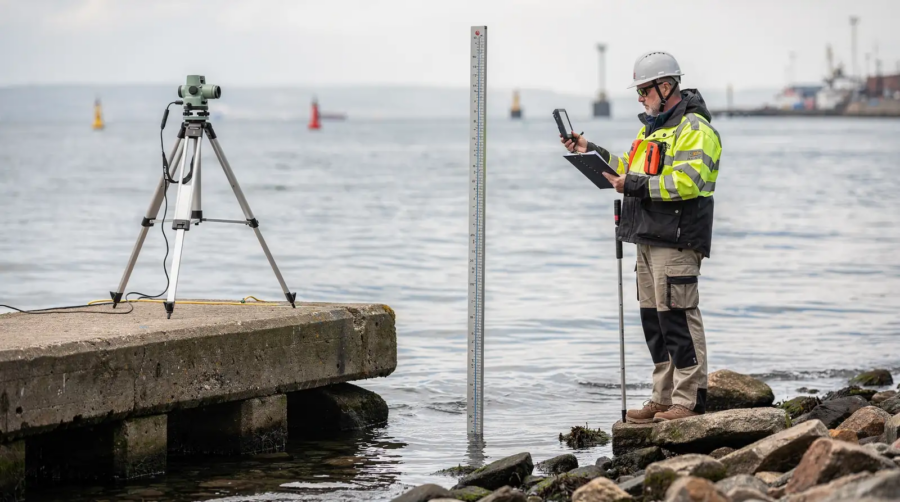
A tidal datum survey measures local water levels to establish a vertical reference surface for mapping, construction, navigation, and coastal management. This reference surface, called a tidal datum, provides the baseline used to calculate elevations, depths, dredging limits, flood risk, and shoreline conditions near coasts and navigable waterways.
NOAA defines a tidal datum as a standard elevation based on a certain phase of the tide. Tidal datums are local reference systems, derived from water-level observations and tied to fixed benchmarks, so they should not be extended into areas with different oceanographic or hydrographic conditions without supporting measurements.
For marine applications, tidal datums serve as reference planes for measuring water depths and heights. They also support nautical charting and the determination of marine boundaries.
How Does NOAA Support Tidal Datum Work?
NOAA’s Center for Operational Oceanographic Products and Services, or CO-OPS, provides national infrastructure, science, observations, and products related to tides, currents, water levels, and coastal oceanography. CO-OPS maintains tidal datums used on nautical charts and publishes station, benchmark, datum, and water-level information for U.S. coastal areas and territories.
NOAA tidal datum calculations rely on long-term water-level observations. The National Tidal Datum Epoch, or NTDE, is a 19-year period used to calculate mean tidal values such as Mean High Water, Mean Low Water, and Mean Lower Low Water.
Mean Lower Low Water, or MLLW, is the chart datum used for U.S. coastal waters and serves as an important reference for nautical charting and depth-related applications.
What Makes a Tidal Datum Survey Accurate?
A tidal datum survey depends on ground control that ties water-level measurements to known, land-based reference points. Field crews establish equipment relative to benchmarks and connect measurements to authoritative horizontal and vertical control networks.
CompassData can cross-check Ground Control Points against established networks such as Continuously Operating Reference Stations, or CORS, and national geodetic databases. This supports the reliable, documented control needed for harbor infrastructure, shoreline mapping, coastal-zone management, and other projects where horizontal and vertical alignment matters.
Who Uses Tidal Datum Surveys?
Tidal datum surveys are used by a wide range of coastal and marine stakeholders, including:
- Port authorities planning and maintaining navigation channels
- Dredging contractors calculating excavation volumes and required depths
- Coastal engineers designing seawalls, bulkheads, piers, and resilient infrastructure
- Hydrographic survey teams producing bathymetric and nautical-charting data
- Government agencies managing shorelines, flood hazards, and marine boundaries
- Environmental teams monitoring erosion, habitat change, and coastal resilience
In each case, the goal is the same: connect land, water, and seafloor measurements to a consistent and defensible reference frame.
How Does Harbor Infrastructure Mapping Work?
Harbor infrastructure mapping uses accurately surveyed control to support navigation, dredging, construction planning, asset management, and marine boundary determinations. It can include piers, seawalls, breakwaters, docks, channels, berths, aprons, shoreline structures, utilities, navigation aids, and other critical facilities.
Reliable water-level data and tidal datums provide an essential foundation for many harbor activities. NOAA CO-OPS products support coastal work by providing water-level observations, tidal datums, published benchmarks, water-level predictions, and related geospatial data.
Without dependable ground truth, positional and elevation errors can affect downstream decisions about channel depth, berth placement, dredging quantities, sediment management, flood protection, and infrastructure design.
What Role Do Ground Control Points Play in Harbor Mapping?
Ground Control Points anchor every layer of a harbor map to real-world coordinates. Survey teams collect these points using high-precision GNSS equipment and, when necessary, total stations. Depending on the project’s location, accuracy target, access conditions, and feature type, crews may use static, rapid-static, or RTK surveys.
This survey-grade control helps keep aerial imagery, mobile mapping, LiDAR, bathymetry, GIS layers, and engineering drawings aligned to the same coordinate reference system.
Can Existing Infrastructure Serve as Ground Control?
Existing infrastructure can sometimes serve as naturally occurring ground control features when temporary targets are difficult to deploy. Piers, seawalls, breakwaters, dock corners, fixed bollards, and other stable, surveyable features may provide useful references for specific coastal mapping applications.
However, natural or existing features should be evaluated carefully for stability, visibility, accessibility, and suitability for the required accuracy. They are not always a substitute for purpose-surveyed Ground Control Points, particularly when a project requires documented precision, repeatability, or formal accuracy reporting.
CompassData provides full documentation with each GCP delivery, including coordinates in relevant formats, metadata, site sketches, field photos, and detailed accuracy reports. For harbor mapping, tidal datum survey, coastal mapping ground control, and bathymetric workflows, that documentation helps teams understand exactly how each point was collected, processed, and validated.

What Is Bathymetric Control for Coastal Projects?
Bathymetric control provides the vertical reference needed to integrate underwater elevation data with shoreline, infrastructure, and terrestrial mapping. It helps surveyors and engineers relate seafloor depths to the same reference framework used for land elevations and water-level observations.
Projects near oceans, estuaries, rivers, and the Great Lakes need accurate water-level information and consistent control to measure elevations relative to water. Without this coordination, bathymetric surveys may not align with terrestrial maps, shoreline models, engineering designs, or navigation-related depth requirements.
CompassData supports bathymetric control workflows with professionally surveyed Ground Control Points collected using high-precision GNSS equipment, including dual-frequency receivers and total stations. Each point can undergo a validation process that includes:
- Cross-checking against known control networks, including CORS and national geodetic databases
- Post-processing GNSS data using precise ephemeris corrections
- Horizontal and vertical accuracy reporting
- Quality-control review against the project’s specifications
Why Does Water-Level Variation Matter for Control Points?
Water levels in oceans, estuaries, tidal rivers, and the Great Lakes can vary significantly. A field measurement taken at low tide may not be directly comparable to a measurement taken at high tide unless both are referenced to the appropriate standardized datum.
Tidal datums provide the local vertical reference needed to account for these changes. Tidal datums are local and tied to fixed benchmarks, allowing measurements to be recovered, compared, and applied consistently for water-level measurement and coastal management.
For coastal projects, the objective is not to eliminate natural water-level variation. It is to document and reference measurements consistently so that data collected at different times can be compared, modeled, and used with confidence.
How Do You Choose the Right Ground Control Partner?
Selecting a ground control partner for coastal mapping requires more than choosing a provider that can collect coordinates. The partner should have proven field experience, quality-controlled workflows, strong documentation practices, and the ability to support the coordinate system, vertical datum, accuracy, and access requirements of a coastal project.
The wrong control strategy can introduce positional error that propagates through every downstream deliverable, from shoreline mapping and harbor infrastructure data to tidal datum survey work and bathymetric models.
What Capabilities Should a Partner Offer?
A qualified provider should offer both archive access and custom collection capability. An existing archive can save time and reduce cost when suitable validated points already exist near the project area. New collection remains important when site-specific placement, current conditions, or stricter accuracy requirements call for fresh fieldwork.
CompassData provides a large archive of surveyed GCPs available off the shelf worldwide, as well as new GCP collection and remote options for restricted or inaccessible areas. Its services span satellite imagery, aerial imagery, drone data, LiDAR, mobile mapping, and GCP surveys.
How Does Quality Control Affect the Decision?
Thorough quality control separates reliable control data from coordinates that have not been sufficiently verified. A single incorrect or poorly documented point can introduce systematic error into an entire survey, imagery product, or coastal model.
Ask potential partners how they validate points, document horizontal and vertical accuracy, address datum requirements, preserve traceability, and review data against project specifications before delivery.
Key Evaluation Criteria
- Archive coverage: A substantial validated archive can reduce field time and cost when existing control is suitable.
- Custom survey capability: The provider should be able to collect new control when archive points do not meet project needs.
- ISO-certified workflows: Documented processes support repeatable quality and reliable delivery.
- Coastal datum experience: The team should understand the relationship between geodetic control, tidal datums, benchmarks, and water-level observations.
- Multi-sensor support: Compatibility with aerial imagery, drones, LiDAR, mobile mapping, and bathymetric workflows can simplify project coordination.
- Clear documentation: Coordinates, metadata, field photos, site sketches, and accuracy reports support transparency and audit readiness.
Build a Strong Coastal Mapping Foundation
Coastal mapping requires precise, documented ground control to connect shoreline features, water-level observations, harbor infrastructure, and bathymetric data to a common reference framework. Tidal datums and benchmarks provide the local vertical context, while survey-grade Ground Control Points provide the physical, traceable foundation for mapping and engineering decisions.
Through CompassData’s survey and mapping data services, coastal teams can access professionally surveyed control, new field collection, and quality-controlled accuracy documentation for imagery, LiDAR, mobile mapping, shoreline mapping, and marine infrastructure projects.
Whether you are planning a tidal datum survey, supporting a harbor expansion, coordinating bathymetric control, or improving the accuracy of a coastal mapping program, contact our team today to discuss your project requirements.